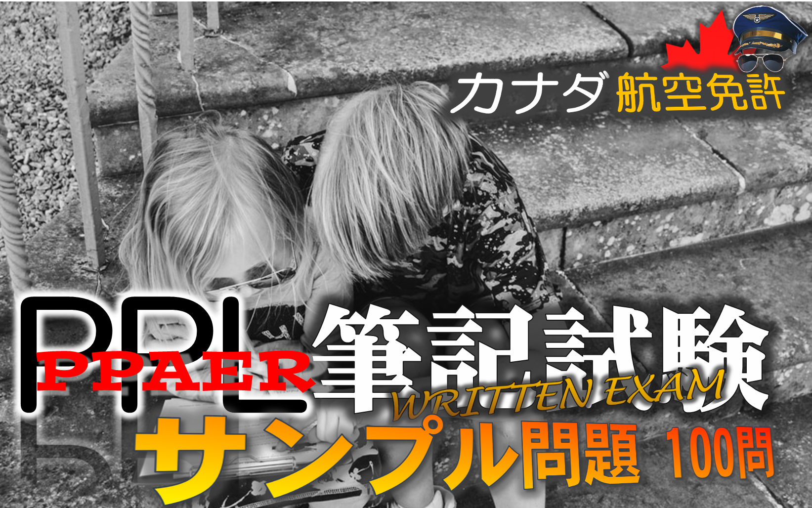
サンプル問題の公開について
カナダ運輸省(TC)は、自家用操縦士免許(PPL)の筆記試験に限り、学生が勉強の準備を効率的に進められるように必死機試験のサンプル問題を公開してくれています。

当記事は、2008年11月公開の第4版を元に作成されています。
この問題は、レクリエーショナルパイロットの許可証の取得を目指す方にも対応しています。出題範囲と出題順序は両試験とも同じが、問題数が異なります。
| 免許の種類 | 問題数 |
|---|---|
| レクリエーショナルパイロット許可書(RPP) | 80問 |
| 自家用操縦士免許(PPL) | 100問 |
本記事では、原文のまま英語で記載しています。
解答は、白いボックスの「 」の中に白字で記載していますので、反転表示をさせるか、選択して読み取り、活用してみてください。
iPhoneとかだとちょっと面倒なんですが、ドラッグして青表示にしてから「調べる」で分かります。
航空気象と航法で使用する読み取り資料は、各章の下の方にまとめて添付しています。

航空法 (AIR LAW)

- the same as a control area.
- controlled airspace around an aerodrome that extends vertically from the surface to 3,000 feet AGL.
- always Class D airspace.
- controlled airspace along airways above 2,200 feet ASL.
解答→「 2 」
- There would be no violation, provided the lights were in the centre of the landing area.
- There would be no violation, provided the aeroplane was equipped with a functioning landing light.
- Yes, the CAR for aerodrome minimum lighting would have been violated.
- There would be no violation, provided air to ground communication was available.
解答→「 3 」
- sunrise and sunset.
- one hour before sunrise and one hour after sunset.
- the end of morning civil twilight and the beginning of evening civil twilight.
- the beginning of morning civil twilight and the end of evening civil twilight.
解答→「 4 」
- the operator of the aerodrome.
- a qualified representative of a commercial air service being operated from the aerodrome.
- a Federal Peace Officer.
- the aerodrome UNICOM operator.
解答→「 1 」
- is less than 18 years of age.
- has consumed alcohol or drugs 48 hours prior to take-off.
- is suffering or is likely to suffer from fatigue.
- is over 60 years of age.
解答→「 3 」
- only when no passengers are carried.
- over a built-up area above 2,000 feet AGL.
- within Class F advisory airspace when visibility is 3 miles or greater.
- within Class C advisory airspace when the visibility is greater than 1 NM.
解答→「 3 」
- aeroplanes shall give way to rotary wing aircraft.
- helicopters shall give way to aeroplanes.
- gliders shall give way to aeroplanes.
- power-driven heavier-than-air aircraft shall give way to airships, gliders and balloons.
解答→「 4 」
- alter heading to the right.
- alter heading to the left.
- avoid the other by changing altitude.
- turn on the anti-collision lights.
解答→「 1 」
- unless flying in accordance with an ATC clearance.
- only when flying in VFR conditions.
- except when within visual range of the control tower.
- at all times.
解答→「 4 」
- 500 ft, 500 ft
- 1,000 ft, 2,000 ft
- 2,000 ft, 1,000 ft
- 3,000 ft, 1 mile
解答→「 2 」
- at minimum cruising speed.
- plus 45 minutes at normal cruising speed.
- plus 30 minutes at normal cruising speed.
- and then to a specified alternate.
解答→「 3 」
- a steady red light.
- a series of green flashes.
- an intermittent white light.
- a succession of pyrotechnics showing red and green stars on bursting.
解答→「 1 」
CARs shall produce such document for inspection, upon demand by
- an airport owner or operator.
- any pilot holding a senior licence.
- a peace officer, or immigration officer.
- a pilot holding a valid instructor rating.
解答→「 3 」
- 2, 3
- 3, 4
- 5, 6
- 10, 12
解答→「 3 」
- relieves the pilot of the responsibility for avoiding weather conditions beyond the pilot’s own flying capabilities.
- relieves the pilot of the responsibility of avoiding other aircraft.
- relieves the pilot of the responsibility of complying with the CARs.
- permits a pilot to fly in below VFR weather conditions without complying with instrument flight rules.
解答→「 4 」
- true track.
- true heading.
- magnetic track.
- magnetic heading.
解答→「 3 」
- 1 mile.
- 2 miles.
- 3 miles.
- 4 miles.
解答→「 3 」
- the current altimeter setting of the nearest station along the route of flight.
- 29.92 in. Hg. or 1013.2 mb.
- the station pressure of the nearest weather reporting station.
- the standard altimeter setting.
解答→「 1 」
- 027ºT.
- 270ºT.
- 027ºM.
- 270ºM.
解答→「 4 」
- request a clearance from the appropriate ATC unit immediately after entering.
- establish radio contact with the appropriate ATC unit only when transiting the associated control zone.
- receive a clearance from the appropriate ATC unit prior to entering.
- contact radar service only when taking off or landing at the associated airport.
解答→「 3 」
航空一般知識 (AERONAUTICS – GENERAL KNOWLEDGE)
- an incipient right spin.
- an incipient left spin.
- a steep right spiral.
- a shallow left spiral.
解答→「 2 」
- speed at which the aeroplane can be safely operated in smooth air.
- speed at which full travel of the flight controls may be used without exceeding the design load factor.
- speed at which the aeroplane may be flown with the flaps lowered.
- safe speed at which the aeroplane should be operated.
解答→「 2 」
- remain unchanged.
- decrease in all flight conditions.
- increase in level flight only.
- increase in all flight conditions.
解答→「 4 」
- is higher when flying downwind than upwind.
- increases with altitude.
- decreases with altitude.
- does not change with change of altitude.
解答→「 4 」
- is the same in a co-ordinated turn as in straight and level flight.
- is less in a co-ordinated turn than in straight and level flight.
- is greater in a co-ordinated turn than in straight and level flight.
- increases in climbing turns, decreases in gliding turns.
解答→「 3 」
- too lean a mixture for best operation.
- carburettor icing.
- fouling of the spark plugs.
- detonation.
解答→「 4 」
- a slight loss of power would result.
- there would be no effect on the engine.
- the engine would stop.
- half of the cylinders would not fire.
解答→「 1 」
- increase manifold pressure and enrich the mixture.
- increase manifold pressure and lean out the mixture.
- decrease manifold pressure and enrich the mixture.
- decrease manifold pressure and lean out the mixture.
解答→「 3 」
- -5°C to 15°C, high
- 5°C to 27°C, low
- -21°C to 0°C, low
- -21°C to 0°C, high
解答→「 1 」
- in clear air with high relative humidity at above freezing temperatures.
- only when precipitation is present at freezing temperatures.
- only in cloud with high relative humidity.
- only when water droplets are in suspension in the air.
解答→「 1 」
- detonation.
- backfiring in the induction system.
- fouled plugs.
- pre-ignition.
解答→「 3 」
- a decreased lift/drag ratio.
- a decrease in induced drag.
- an increase in downwash.
- an increase in wing tip vortices.
解答→「 2 」
- the conditions of a standard atmosphere exist.
- a standard lapse rate exists.
- you are in the Standard Pressure Region.
- the barometric pressure is 29.92 in. Hg.
解答→「 1 」
- 1,000 ft too high.
- 1,000 ft too low.
- 100 ft too high.
- 100 ft too low.
解答→「 1 」
- drowziness.
- dizziness.
- euphoria.
- hyperventilation.
解答→「 3 」
- 3 to 5
- 30 to 50
- 300 to 500
- 3,000 to 5,000
解答→「 1 」
- increase with an increase in altitude.
- decrease with an increase in altitude.
- remain the same with an increase in altitude.
- remain constant to 6,000 feet ASL.
解答→「 1 」
- higher
- lower
- closer in
- approaching faster
解答→「 1 」
- slipping and decreasing airspeed.
- skidding and decreasing airspeed.
- slipping and increasing airspeed.
- skidding and increasing airspeed.
解答→「 2 」
- low approach speed.
- shallow approach angle.
- high approach speed.
- strong cross-wind.
解答→「 3 」
- following full power application.
- before rotation.
- following rotation.
- above its flight path.
解答→「 3 」
- increase in groundspeed and increase in lift.
- decrease in groundspeed and loss of lift.
- increase in airspeed and increase in lift.
- decrease in airspeed and loss of lift.
解答→「 4 」
The upper limit of the white arc on an airspeed indicator is the maximum
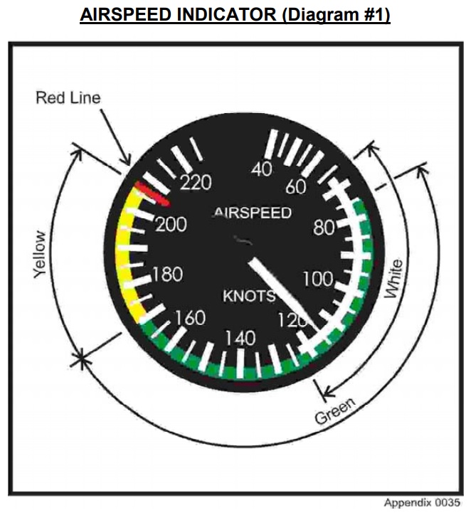
- normal operating speed.
- flap extension speed.
- manoeuvring speed.
- range speed.
解答→「 2 」
The turn co-ordinator indicates that the aircraft is in a
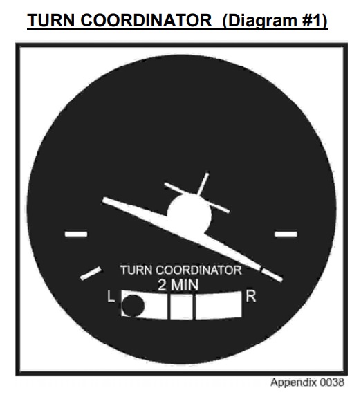
- slipping left turn.
- skidding left turn.
- slipping right turn.
- skidding right turn.
解答→「 4 」
- north and south.
- east and north.
- east and west.
- west and south.
解答→「 3 」
Using the above information, what is the pressure altitude?
- 5,000 ft.
- 4,640 ft.
- 4,560 ft.
- 4,200 ft.
解答→「 1 」
Temperature 20°C
Using the above information, what is the density altitude?
- 7,300 ft.
- 6,100 ft.
- 5,100 ft.
- 4,500 ft.
解答→「 2 」
For a take-off on runway 31 with the wind from 270° at 20 kt, the aircraft would be subject to head wind and cross-wind components respectively of
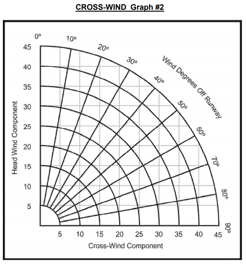
- 20 and 15 kt.
- 15 and 13 kt.
- 15 and 20 kt.
- 13 and 15 kt.
解答→「 2 」
Runway level, dry grass
Aerodrome Pressure Altitude 4,000 ft
Temperature 20°C
Head wind component 9 kt
Aeroplane weight 1600 lb
Using the above data, the total distance to clear a 50 foot obstacle is
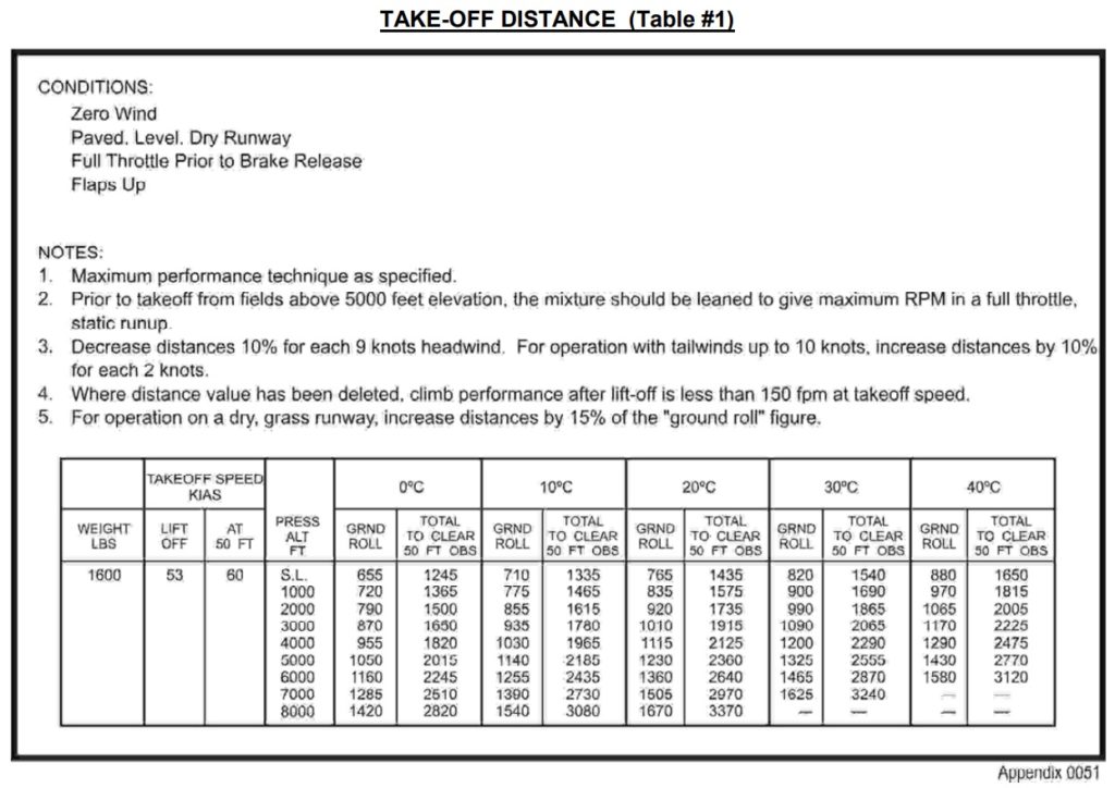
- 1,912 ft.
- 2,063 ft.
- 2,199 ft.
- 2,444 ft.
解答→「 2 」
Using the above data the aeroplane

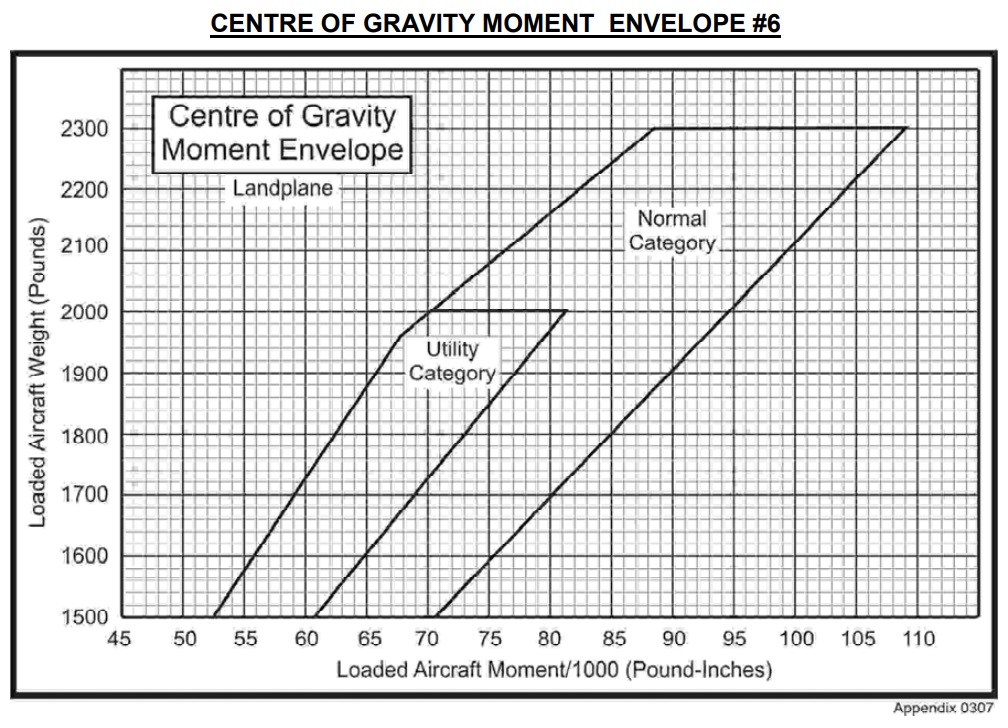
| Load Details | Weight lb. | Moment 1000 lb in. |
|---|---|---|
| Basic empty weight (includes full oil/unusable fuel) | 1,365 | 51.0 |
| Usable fuel at take-off– 38 U.S. gal. | – | – |
| Pilot & front Passenger | 360 | – |
| Two rear seat passengers | 282 | – |
| Baggage | 50 | – |
- is within the weight limits for the utility category only.
- is within the weight limits but is not within the CG limits.
- exceeds both the weight limits and the CG limits.
- is within both the weight and the CG limits.
解答→「 4 」
航空気象 (METEOROLOGY)
- amount of moisture present in the air.
- weight of water present in the air.
- amount of moisture present in the air compared to the amount the air could hold at that temperature and pressure.
- temperature to which the air must be lowered to bring about saturation.
解答→「 3 」
- altostratus.
- altocumulus.
- stratocumulus.
- nimbostratus.
解答→「 4 」
- is cooled by the cold air underneath.
- is cooled by the surrounding cold air aloft.
- becomes unstable as a result of cooling from below.
- cools as a result of expansion as it rises.
解答→「 4 」
- moist air moves from a warm surface to a colder surface.
- the cold ground cools the air in contact with it at night.
- moist air is influenced by orographic effect.
- moist cool air moves from a cold surface to a warm surface.
解答→「 1 」
- passage of cold air over a warm surface.
- air becoming moist as it moves over the sea.
- clouds becoming cold and heavy at night so that they settle to the ground.
- ground becoming cold at night and cooling the air in contact with it.
解答→「 4 」
- clockwise around high and low pressure areas.
- counter-clockwise around high and low pressure areas.
- clockwise around a high pressure area and counter-clockwise around a low pressure area.
- counter-clockwise around a high pressure area and clockwise around a low pressure area.
解答→「 3 」
- veers and increases.
- backs and increases.
- veers and decreases.
- backs and decreases.
解答→「 4 」
- veer and increase in speed.
- veer and decrease in speed.
- back and increase in speed.
- back and decrease in speed.
解答→「 1 」
- 0ºC.
- 5ºC.
- 8ºC.
- 10ºC.
解答→「 2 」
- moist air, high temperature, and an inversion.
- stratus cloud, high humidity and a lifting force.
- unstable air, high humidity and a lifting force.
- a mixing of two different air masses.
解答→「 3 」
- a low pressure area.
- an inversion.
- a reverse temperature condition.
- an inverse convection condition.
解答→「 2 」
- strong winds, cumulus cloud, good visibility.
- uniform temperature, good visibility.
- continuous rain, freezing temperature.
- fog, poor visibility and layer cloud.
解答→「 4 」
- narrow zone of fog between a cyclone and an anticyclone.
- line of thunderstorms.
- narrow transition zone between two air masses.
- mass of layer cloud which is very thick and which covers a wide area.
解答→「 3 」
- warm air is compressed as cold air rides over it.
- temperature rises owing to increased pressure.
- fog will always form from the interaction of warm and cold air.
- warm air is lifted as colder air pushes under it.
解答→「 4 」
- the passage of a cold front.
- anticyclonic weather.
- the passage of a warm front.
- clearing skies and a decrease in temperature.
解答→「 3 」
- feet AGL.
- feet ASL.
- metres AGL.
- metres ASL.
解答→「 1 」
- too high.
- too low.
- the pressure altitude.
- the true altitude.
解答→「 2 」
The average wind applicable to a direct flight from Winnipeg (CYWG) to Brandon (CYBR) at 5,500 ft would be
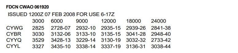
- 290°M at 30 kt.
- 290°T at 30 kt.
- 310°M at 31 kt.
- 310°T at 31 kt.
解答→「 2 」
- 5
- 10
- 15
- 20
解答→「 4 」
The center of the low pressure system is . . . . . between 1800Z and 0000Z.
- stationary
- moving south-easterly
- moving north-westerly
- moving easterly
解答→「 2 」
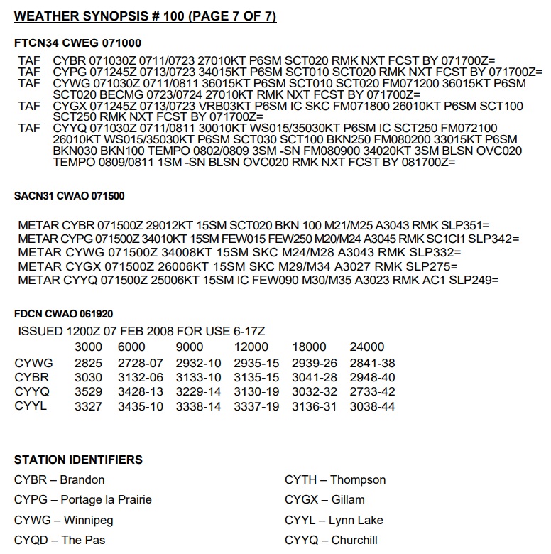
This forecast covers a period of . . . . . hours and includes a . . . . . hour IFR outlook.

- 24, 12
- 24, 6
- 12, 12
- 12, 24
解答→「 3 」
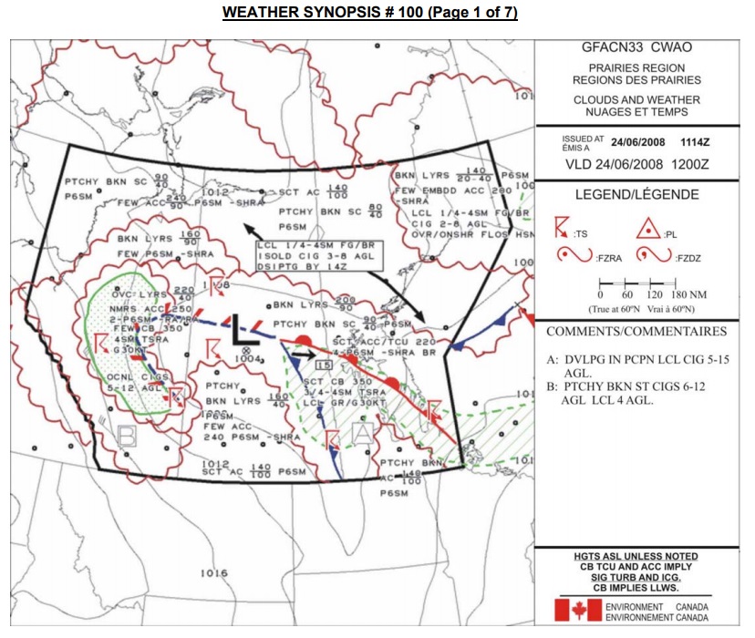
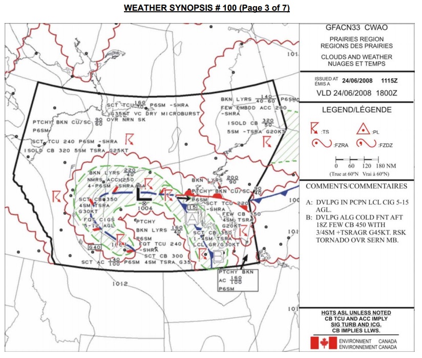
The cloud condition at Churchhill (CYYQ) is forecast to
- remain clear.
- thicken and lower.
- remain scattered until 0900Z.
- become overcast at 200 ft.
解答→「 2 」
The forecast visibility at Churchhill (CYYQ) between 1500Z and 2100Z is
- 15 SM in wet snow.
- 15 NM in wet snow.
- greater than 6 NM.
- greater than 6 SM.
解答→「 4 」
The Gillam (CYGX) aerodrome forecast covers a period of . . . . . hours.
- 24
- 12
- 10
- 6
解答→「 3 」
The Gillam (CYGX) 1800Z wind is forecast to be
- 260°T at 10 kt.
- 260°M at 10 kt.
- variable at 3 kt.
- calm.
解答→「 1 」
The 1500Z Portage La Prairie (CYPG) METAR indicates that the
- visibility is greater than forecast.
- ceiling is lower than forecast.
- winds are weaker than forecast.
- ceiling is as forecast.
解答→「 3 」
The ceiling at Brandon (CYBR) at 1500Z is
- 200 ft.
- 1,000 ft.
- 2,000 ft.
- 10,000 ft.
解答→「 4 」
The 1500Z temperature/dewpoint spread at Portage La Prairie (CYPG) is
- 24°C.
- 20°C.
- 15°C.
- 4°C.
解答→「 4 」
The altimeter setting at Winnipeg (CYWG) is
- 30.43 in. Hg.
- 30.43 mb.
- 933.2 in. Hg.
- 1332.0 mb.
解答→「 1 」
- expected at a station at a given time.
- expected at a station over a 12 hour period.
- observed at a station at the time of the report.
- observed at a station during the previous day.
解答→「 3 」
航法 (NAVIGATION)

- 078°M.
- 070°M.
- 062°M.
- 054°M.
NOTE: For questions 82 to 100 inclusive, refer to the Appendix, CROSS-COUNTRY FLIGHT and to the Toronto VNC Chart.
解答→「 4 」
What is the distance between the following two geographic co-ordinates: N44º00’ W78º00’ and N45º00’ W78º00’?
- 10 NM.
- 10 SM.
- 60 NM.
- 60 SM.
解答→「 3 」
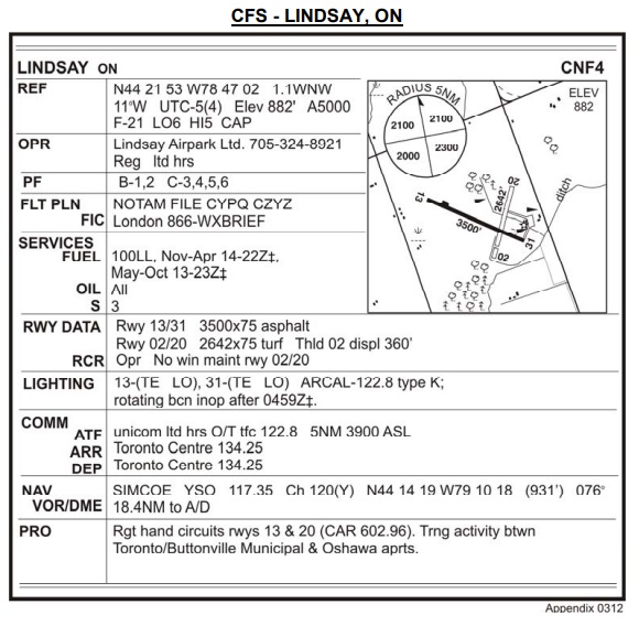
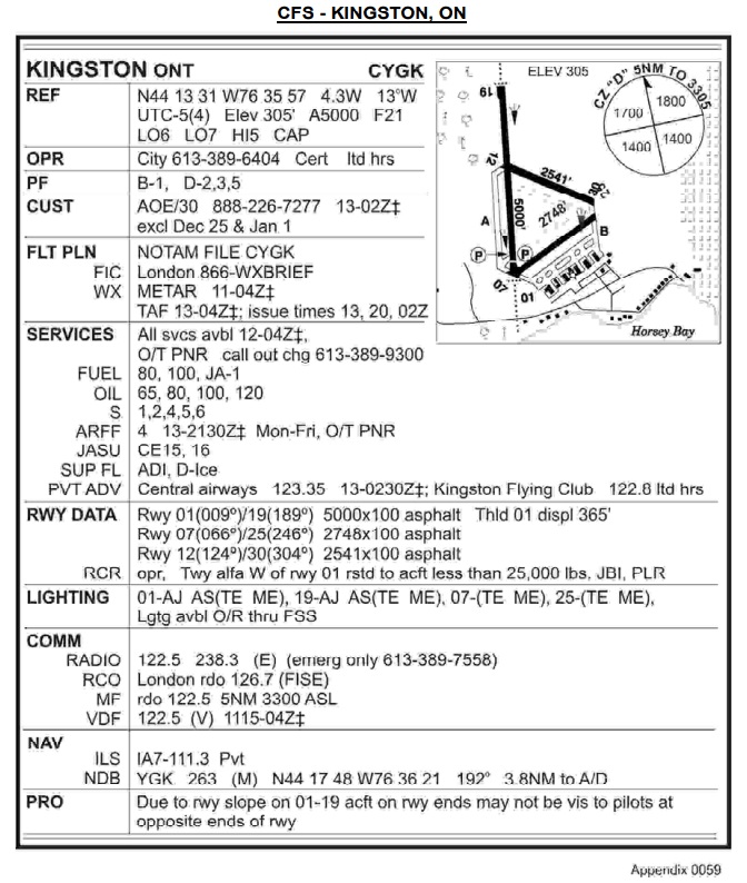
Select the correct statements with respect to the aerodrome information.
A. Circuits are right hand on runways 13 and 20.
B. Aircraft radio controlled aerodrome lighting is available.
C. There are PAPI lights on runways 31 and 13.
D. Customs service is available.
E. There is an FSS at the aerodrome.
F. Aviation gasoline is available.
- A, B, F.
- B, E, F.
- C, D, F.
- A, B, D.
解答→「 1 」
The hypsometric tinting on the chart indicates that between the Lindsay and Gananoque aerodromes the flight will be conducted over ground which is between
- sea level and 1,000 ft.
- sea level and 1,500 ft.
- 1,000 ft and 2,000 ft.
- sea level and 2,000 ft.
解答→「 1 」
True Air Speed 105 kt.
Track 010°T
Using the above information the computed heading and groundspeed en route Oshawa to Lindsay is nearest to
- 010°M and 105 kt.
- 360°M and 112 kt.
- 012°M and 114 kt.
- 031°M and 105 kt.
解答→「 3 」
En route from Oshawa to Lindsay you pass through CYA 520(T). You must be more alert for
- aircraft on approach to Lester B. Pearson International Airport (Toronto).
- civilian flight training activity.
- aerobatic activity.
- military flight training activity.
解答→「 2 」
What is the magnetic track from Lindsay (CNF4) to Gananoque (CNN8)?
- 281°.
- 077°.
- 089°.
- 101°.
解答→「 4 」
The estimated flight time from Lindsay to Gananoque at 5,500 ft with a groundspeed of 100 kt is nearest to
NOTE: Add an extra 2 minutes for each 1,000 ft of climb.
- 1 hour and 05 minutes.
- 1 hour and 15 minutes.
- 1 hour and 20 minutes.
- 1 hour and 25 minutes.
解答→「 2 」
Total flight time 1 hour and 50 minutes
Add 2.0 gal for taxi, take-off and climb at Lindsay.
Using the above information, calculate the day VFR fuel requirements for a flight from Oshawa to Gananoque with a stop at Lindsay.
NOTE: Add 2.0 gal for taxi, take-off and climb at Oshawa.
- 18.1 gal.
- 16.9 gal.
- 14.1 gal.
- 12.8 gal.
解答→「 2 」
Outside Air Temperature 15°C
Indicated Airspeed 100 kt
Using the above information, what is the true airspeed? Assume indicated airspeed is equal to calibrated airspeed.
- 89 kt
- 94 kt
- 106 kt
- 113 kt
解答→「 4 」
The highest obstacle within 5 NM either side of your track from Lindsay to Gananoque is
- 1,857 feet ASL.
- 1,600 feet ASL.
- 1,475 feet ASL.
- 1,246 feet AGL.
解答→「 1 」
While on track abeam Peterborough (N44º13’ W78º21’), you wish to obtain the latest weather for Kingston (N44º13’ W76º35’) to get some indication of what conditions will be at Gananoque.
What would be the most appropriate station and frequency to call for this information?
- Peterborough UNICOM 122.8 MHz.
- London Radio 126.7 MHz.
- Campbellford Radio 113.5 MHz.
- Trenton Tower 128.7 MHz.
解答→「 2 」
Your aircraft crosses the town of Bridgenorth (N44°23’ W78°23’) at 1810Z.
At 1822Z your aircraft is abeam the town of Norwood (N44°23’ W77°59’).
Your ETA at Gananoque aerodrome will be closest to
- 1902Z.
- 1908Z.
- 1914Z.
- 1920Z.
解答→「 3 」
You are north of track over the town of Marlbank (N44°26’ W77°05’). Using the opening and closing angles method, you should alter heading to the right
- 2°.
- 5°.
- 8°.
- 10°.
解答→「 2 」
What class of airspace would you be flying through when your aircraft is at 5,500 feet ASL, over Marlbank (N44°26’ W77°05’)?
- D.
- E.
- F.
- G.
解答→「 2 」
With the VOR receiver tuned to the Coehill VOR (N44º40’ W77º50’), when you are over the town of Marlbank (N44°26’ W77°05’) the CDI should be
- centred with a “FROM” indication when the OBS is 123°.
- centred with a “FROM” indication when the OBS is 303°.
- deflected full left when the OBS is 123°.
- deflected full right when the OBS is 303°.
解答→「 1 」
Due to deteriorating weather you decide to divert to Kingston (N44º13’ W76º35’), but you become disoriented. To assist in locating the airport, Kingston FSS could give you a
- radar vector.
- ADF steer.
- DF steer.
- VOR vector.
解答→「 3 」
- 30 minutes after the last reported ETA.
- 1 hour after the last reported ETA.
- 12 hours after landing.
- 24 hours after landing.
解答→「 2 」
What class of airspace is CYR 503, located 3 NM east of the Kingston airport
(N44º13’ W76º35’)?
- D.
- E.
- F.
- G.
解答→「 3 」
The reported ceiling at Kingston is 1,000 ft broken and visibility is 4 miles.
To remain VFR in controlled airspace, an aircraft must join the circuit at Kingston
- at 800 ft ASL.
- at 1,300 ft ASL.
- in accordance with SVFR.
- as high as possible without entering cloud.
解答→「 1 」